Today we received a notice from our township supervisor alerting us to a proposal to expand the current Chisago Lakes Improvement (taxing) District [LID] to align with a new and improved watershed boundary. If the expansion is approved, properties newly added to the district will probably see an increase in taxes. Today's posting isn't about a tax increase however. That may or may not be the issue. I don't understand why the County Commissioners and the LID board can't provide a detailed set of maps that clearly delineates which properties are in and out of the current and proposed district and why. Here's some background:
- The Chisago Lakes Lake Improvement District and the Chisago County Commissioners are proposing to adjust the boundary of the LID.
- From the maps they provided as links, I can't tell whether or not my property (which is located along the western boundary of the watershed) is in the "official 2009 Chisago Lakes Chain of Lakes Watershed developed by the Minnesota Department of Natural Resources" or just across the line in the Carlos Avery Unit.
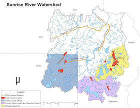
- The area I'm particularly interested in lies between County Roads 19 and 80 on this map. The text and the legend don't make it clear how DNR delineated the western watershed boundary and what the dashed and red lines in the area of interest are supposed to show.
The Sunrise River watershed isn't identified on this map
Further troubling my impression of a lack of rigorous accountability and focus on mission are these statements on the LID's web site:
"The Chisago Lakes Lake Improvement District partners with other organizations such as Chisago Soil & Water Conservation District, local communities, lake associations, state and federal agencies.... The following fact sheets highlight 2014 Chisago Lakes Lake Improvement District activities that benefit lakeshore, non-lakeshore, city, and rural residents.
- 295th Street Neighborhood Retrofit – Lindstrom
- Aquatic Invasive Species Treatment
- Chisago County Children’s Water Festival
- Chisago County Water Quality and Aquatic Invasive Species Monitoring
- Chisago Lakes Watershed Best Management Practices Implementation
- Carp Management
- Ditch and Weir Maintenance
- Fish Kill Disposal
- Furgala/Labernik Rain Garden – Center City
- Groundwater Observation Wells
- Hook, Line and Sinker Recycling Program and Summary
- Lake Avenue Dead End Street Project – Chisago City
- Lake Level Monitoring Program
- Lake Level Graphs
- Summary for Chisago Lakes Chain of Lakes Watershed lake level monitoring activities
- Lake Water Quality Monitoring
- Loren’s Park – Center City
- Minimal Impact Design Standards
- North Center North Lindstrom Channel
- Pleasant Hill Park – Lindstrom
- Public Outreach and Awareness
- Pumphouse Park/Elm Street Project – Lindstrom
- Rural Subwatershed Assessment
- Septic System Compliance
- Slow No-Wake Ordinance
- South Center Lake Boat Launch – Lindstrom
- Surfland Neighborhood Rain Gardens – Chisago City
- Swamp Lake Outlet Easements
- Urban and Shoreline Best Management Practices
- Water Trail System
- Watercraft Inspection Program
- Watercraft Inspection Report"
The yellow area is the Chisago Lakes District
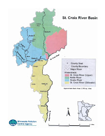
Perhaps I wouldn't be as disturbed as I am if I hadn't recently been reading the Watershed Restoration and Protection Strategy Report for the Sunrise River Watershed, prepared by the Minnesota Pollution Control Agency. The Chisago Lakes watershed is part of the Sunrise River watershed, which is part of the Lower St. Croix River Watershed that is part of the Mississippi River Watershed. The WRAPS report notes
"Many key partners have been brought together to make this WRAPS Report a useable document that will ultimately help us to meet the goals of the Sunrise River Watershed and the Direct Drainage to the St. Croix River. These groups include: Anoka CD, Chisago SWCD, Isanti SWCD, Washington CD, Chisago County, MN DNR (Fisheries and Eco/Waters), MPCA, City of North Branch, City of Stacy, City of Wyoming, City of Shafer, City of Taylors Falls, USDA NRCS, Sunrise River Water Management Organization, Comfort Lake-Forest Lake Watershed District, Chisago Lakes Lake Improvement District, Linwood Lake Association, and Friends of the Sunrise River. These groups have collaborated with the Chisago SWCD to provide comments and additions specific to their subwatersheds. This collaboration will prove to be pivotal in applying for funding in the future to complete projects in each constituent’s jurisdiction."
Here's my basic complaint: Nowhere can I find a clearly laid out matrix of which agency or agency is responsible for which issue in which jurisdiction. Nowhere can I find a coordinated work program and budget that aligns resources with priorities. I'm not suggesting that all these folks aren't doing good and necessary work. I am stating unequivocally that we, the taxpayers and resource users, don't know. We'll report back here from time to time as we, hopefully, make some progress on this.
Issa’s Cricket
On a branch
floating downriver
a cricket, singing.
Issa (Japan, 1763-1827)
[translated by Jane Hirshfield]
********************************************
Thanks for visiting. Come again when you can.
Please be kind to each other while you can.


No comments:
Post a Comment